Vancouver Public Library
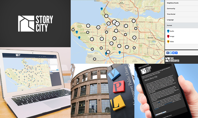
Story City - Vancouver Public Library
With funding from Canada 150 Fund, Vancouver Public Library (VPL) collected over 400 new audio recordings to add to the hundreds of photographs, videos, and scanned historical documents in its existing This Vancouver digital asset repository. VPL sought to develop an interactive map interface and website to aid the promotion, discoverability, and consumption of a curated version of This Vancouver, called Story City.
Client
Vancouver Public Library has been dedicated to meeting the lifelong learning, reading and information needs of Vancouver residents for more than 100 years. Last year, VPL had nearly 6.5 million visits, with patrons borrowing nearly 9.5 million physical and digital items including books, ebooks, movies, music and magazines. Across 21 locations, VPL is the most-visited major urban library per capita in Canada.
Challenge
The Story City solution needed to geographically plot the new audio recordings plus other digital assets stored in This Vancouver relating to places, migration, and movement of people to the city. A key challenge to overcome was restricted access to VPL’s technical infrastructure.
Solution
The finished product Story City map interface presents on an attractive, social-sharing friendly, responsive website. Pins or other visual identifiers on a layered map of Vancouver indicate the presence of a digital asset (video, interview, image). Each object is geotagged with metadata so as to be searchable by keyword or limited by facets of neighbourhood, era, community background, format, and language and makes for easy discoverability of content.
The unusual circumstance of restricted access to VPL’s technical infrastructure limited the ability to deploy iteratively, which typically is not recommended. To mitigate the associated risks with this, Digital Echidna verified development workflow as early as possible, and as a proof of concept, deployed an early version of the map solution to the live VPL environment.
For the mapping feature to work, Digital Echidna developed a new Islandora module (story_map). This module takes Islandora content objects and pins them to a map using the data from the location fields within said objects. Content objects were geotagged with the appropriate coordinates, as well as other associated metadata and tags for search facets. The interface handles aggregation of multiple pins into clusters, which drills down to a more
detailed view when the user clicks.
This is a very visual-dependent module. The pins for different types of content are visually distinct; when the user clicks on an individual pin, a high-level description is offered. Another click will open the media for the object in the appropriate viewer/player, lead to a more in-depth description, and easily return to the map to explore other pins or to explore another search facet. Upon completion of this site, the new module (called story_map) was contributed
to the Islandora Foundation.
Key Factors of Success
-
Development of map-based web delivery solution for Islandora content
-
IP Geolocation Views & Maps and Leaflet. The IP Geolocation (a.k.a the mapping engine) takes the data from Islandora Solr Views and displays it on a Leaflet map (a.k.a the map renderer)
-
Graphic design based on VPL’s branding and supplied pattern libraries
-
The map presentation solution can be reused in future by VPL to present other collections